Searching for lost things can derail your lean management efforts. It not only wastes time but also eats into productivity. Case in point, 37% of nurses that responded to a survey claimed to have spent anywhere between one to six hours searching for items at work. The same storyline applies to various professionals, from engineers to regular factory workers. With RTLS system technology, no one has to worry about searching for their items anymore. The world of real-time location tracking systems is constantly changing, with new use cases coming up often. Lucky for you, you just landed in the right place if you’re new to the industry. Read on to learn some more about real-time location tracking systems:
An overview of RTLS system
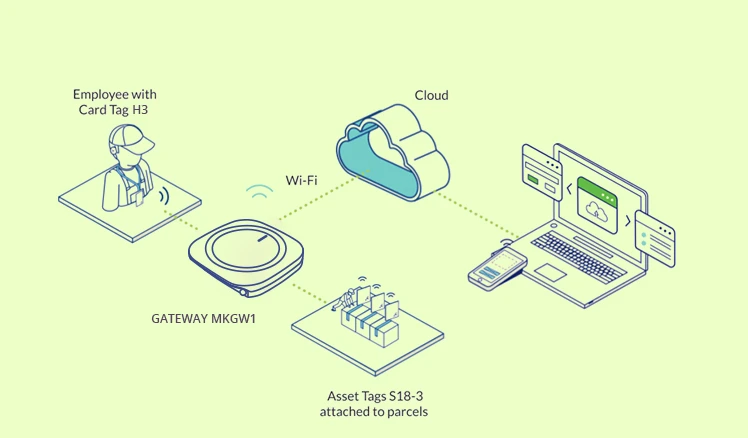
A real time tracking system is a combination of technology solutions that help automatically track the location of specific assets, all in real-time. It generally works by placing tags on the item or asset that needs to be tracked. This way, a manager can easily know where to find the thing, whether it is a package, people, large machinery, or equipment.
Once the tagged asset moves, the tags send out the location data to receivers placed in specific locations. The data received by the receivers provide enough data on the tag’s location along with the tagged item. The digital version of this data is stored in RTLS software.
When combined with the right software, this data can provide a lot of information, including interactive maps, heat maps, locating tools, and dashboards. However, the effectiveness of each solution will depend on the features provided by its software.
By identifying the specific location of specific items, processes can be streamlined. This also allows employees to focus on more intensive tasks instead of spending valuable time looking for assets. Different industries will need to track different items, and the RTLS solution must-haves vary for each industry.
The origin of RTLS
RTLS was the brainchild of three individuals; Jay Web from PinPoint, Tim Harrington from WhereNet, and Jay Werb from AIM. Their goal was to create a technology that combined the automatic identification capabilities of active RFID tags and the ability to display the information on a computer screen.
They created the concept at the ID EXPO trade show, where WhereNet and PinPoint showcased real-world examples of RTLS systems that were commercial-based. At first, RTLS technology had been too expensive for normal businesses to use, and government agencies and militaries were the dominant adopters.
It was in the early 1990s that this technology trickled down to commercial end-users, with three healthcare facilities in the US installing the first commercial RTLS real time location system. Since then, new technologies have been emerging, making the application of RTLS to passive tag applications possible.
RTLS locating concepts
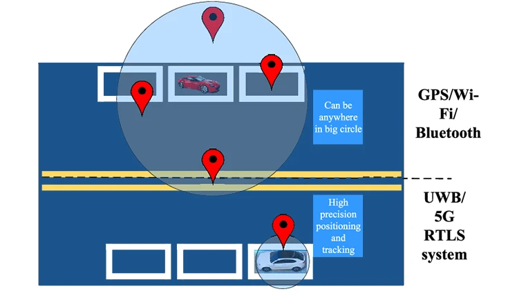
Unlike GPS, RTLS does not provide global coverage. It is instead used indoors or within confined areas of interest. Its tags are attached to mobile items that need to be tracked, with the transmitter or receiver being used as reference points. The transmitters and receivers are often spaced throughout the area of interest. In most cases, having more RTLS reference points means that your system will provide better location accuracy up to the point of their technological limitations. There are two main system design elements for RTLS systems:
- Locating at a choke point
In its simplest form, chokepoint locating relies on the short-range ID signals coming from a mobile tag being received by a sensory network through a single fixed reader, which helps indicate the location of the item in relation to the tag and the reader. Alternatively, the moving tag can receive the choke point identifier before being relayed to a location processor, usually with the help of a second wireless channel.
The accuracy of the location system will typically depend on the spherical reach of the receiver or choke point transmitter. The use of directional technologies or antennas, like ultrasound and infrared that are typically blocked by room partitions, can easily provide support for choke points of various geometries.
- Locating relative coordinates
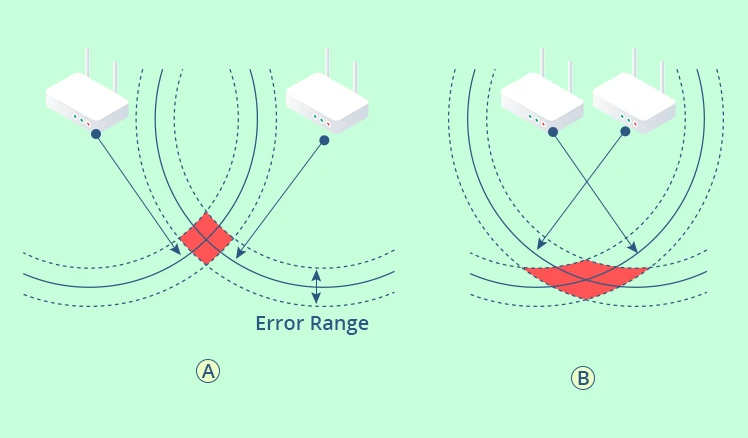
In this case, a tag’s ID signals will be received by many readers within a sensory network. The network then estimates the position of the tag with the help of a locating algorithm like multilateralism, trilateration, or triangulation.
Alternatively, the tag can receive the ID signals of multiple RTLS reference points before relaying them to a location processor. The distance between the reference points within the sensory network needs to be known to make locating items or assets as precise as possible. The last way to calculate relative location is when the tags on mobile items directly communicate with each other before relaying the data to a location processor.
- Location accuracy
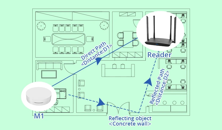
RF triangulation estimates a tag’s location by using the angle at which each RF signal reaches multiple receivers. On the other hand, RF trilateration locates tags by estimating the ranges of the different receivers. Since there are multiple obstructions that can distort the estimated range, like walls and furniture, estimation-based locating is often rated according to accuracy at specific ranges. For instance, a system could be said to give 90% accuracy within a ten-meter range.
RTLS Components
Application and technical standards will vary between RTLS platforms, but all platforms share the same basic software and hardware components:
- Transmitters: depending on the form factor used, transmitters can be referred to as badges, transponders, or tags. They are attached to an asset or individual from where they send location and identification data over a wireless signal to receivers.
- Receivers: these are positioned in different areas within a facility and are meant to receive the signals forwarded by the tagged assets to identify their location. Depending on the kind of wireless standard they run under, they can determine the location in two ways; through trilateration (a mathematical process) or by estimating the tag’s proximity to the receivers. Location calculation is determined by the time the tag’s signals take to reach multiple receivers.
- Management portals: once they receive the data, the receivers then send it out to a central management system. From this portal, connected computer systems and human operators can track and analyze the location data.
While different tracking systems will offer varying capabilities, each RTLS solution is bound to offer longer-term logging and real-time tracking. They could have other capabilities, such as configuring a geofence. Geofences are meant to act as virtual boundaries whose supporting RTLS receivers will send out alerts if a tagged item or person crosses it.
RTLS hardware
The RTLS hardware needs to be in communication with the tracking devices for RTLS solutions to work. The devices that will be in constant communication with the trackers are called anchors, and they need to be strategically placed within different parts of the location of interest, such as buildings.
The number of anchors to be used at a specific location is contingent on the types of trackers used. In case you are using active RFID, you will need to use fewer anchors to cover a large space. On the flip side, more anchors will need to be installed if you are using BLE and passive RFID.
RTLS’ privacy and security concerns
RTLS solutions can easily lead to privacy and security concerns. The fact that they allow managers to track employee locations can be perceived as an invasion of privacy. They allow people to not only track real-time location data but also draw insights from historical location data. That’s why there are numerous regulations that have been developed recently, like the GDPR, that aim at improving privacy and security.
For instance, these regulations limit the kind of data an organization could store about someone, as well as how they use it. While the effects of these regulations could be limited in organizational settings, they are a good place to start. Besides, they can provide enough coverage when combined with other internal privacy regulations.
The fact that RTLS solutions add another point of entry into any organization’s IT ecosystem makes focusing on their security posture essential. Organizations should both buy solutions from RTLS vendors with a strong cybersecurity record and implement their own internal security strategies to remain safe from data breach threats.
Types of RTLS technologies
- GNSS/GPS
The Global Navigation Satellite System (GNSS) provides wide-area coverage on a global scale with the help of a satellite system, making it ideal for outdoor tracking. Using GNSS for location tracking and monitoring will require combining satellites with GNSS tags that have Bluetooth, Wi-Fi, or cellular connectivity. A GNS smart device or tag will receive data from multiple orbiting satellites about their location and time. It then uses this data to identify the mobile device’s location before sending out the data to a cloud database or a host computer.
- Bluetooth low energy
The fact that Bluetooth is a standard technology makes it one of the best technologies to use for RTLS implementation. You will mainly have to set up Bluetooth RTLS tags or beacons in the area of interest, where they will broadcast information to receivers on smart devices or other BLE RTLS beacons and tags. The receiver then relays the data to a gateway that sends it to a cloud database or a host computer.
- Infrared radiation
Infrared-based RTLS are ideal for situations that need high room-level accuracy and low deployment costs. Since infrared waves can’t go through walls, the technology can only be used within a small room, but combining it with Bluetooth and Wi-Fi can counter these limitations. The infrared receivers that are mounted at specific locations will pick up each tag’s signal before relaying it to a cloud/networked database of the host computer via Wi-Fi or LAN.
- Active and passive RFID
There are two types of RFID technologies, active and passive RFIDs. The latter has no internal power source, and it relies on the electromagnetic waves from RFID readers to power it. The former has its own power source that allows it to constantly broadcast a signal. Both systems can be used in location tracking, whereby active RFID is ideal for real-time asset location tracking while the latter is ideal for access control and inventory control.
- Ultrasound radiation
This technology is ideal for room-level positioning since ultrasound waves cannot pass through walls, similar to infrared radiation. However, it differs from infrared radiation in that it uses sound to locate the asset. Receivers have microphones that pick sound while tuned into the ultrasound frequency band.
- Ultra-wideband
RTLS UWB devices are often sending out radiofrequency energy into the environment with the aim of the receivers picking them up. In order to improve accuracy in large areas, many receivers have to be placed close to each other, with sub-receivers being placed in between them. This is because the tags’ signals are short, making this option ideal for accurate zone-level and room-level location tracking.
- Vision
These systems leverage cameras and real-time/live images to monitor people and assets. The high-end cameras can be outfitted with additional technology like Bluetooth or Wi-Fi to allow the system to share images and timestamp data with networked/cloud databases or host computers. The RTLS solution’s quality is highly contingent on lighting, camera quality, and visibility.
The thing that makes this type of RTLS solution ideal is that end users can easily leverage pre-existing Wi-Fi access points without incurring extra hardware costs. Smart devices or Wi-Fi RTLS tags use their internal Wi-Fi radios to relay signals to Wi-Fi access points within an area. The system uses several positioning indicators to enumerate distances from the Wi-Fi access points.
The ideal RTLS to use will depend on your intended purpose. These include:
- Precision-based RTLS
Based on Wi-Fi or ultra-wideband technologies, this type of RTLS could help you identify the exact location of an item. It is ideal for tasks like inventory management that require identifying where an item is to the centimeter level. The drawback is that these solutions tend to be quite expensive and require many infrastructures to drive this level of accuracy.
- Proximity-based RTLS
This system isn’t as accurate as precision-based RTLS, but it can provide location data within a couple of feet. It is ideal for situations where identifying the precise location of an asset isn’t a necessity. For instance, when searching for an x-ray machine in a hospital, you only need to know the room it is in, but not the exact spot. These solutions tend to be less expensive and require fewer infrastructures to optimize.
Critical factors in RTLS system accuracy
Ranging and Angulation
The ranging and/or angulation method used for location tracking will depend on the physical technology you use. Sometimes, you might need to merge multiple ranging and angulation methods. The most common ranging and/or angulation methods include:
- The angle of arrival and angle of departure – is calculated by measuring individual elements’ (Signal) time difference between arrival and departure
- Line of sight – calculated by measuring the distance between the transmitter and receiver
- Time of arrival – calculated by estimating the time it takes for a signal to get from the transmitter to the remote receiver
- Time of flight – calculated by measuring the time signal takes to go through a specific medium.
- Multilateration – measures an asset’s location based on the transmitters’ signal time of arrival in conjunction with waveform details and speed.
- Symmetrical double-sided two-way ranging – Uses two delays in signal transmission to calculate the range between a receiver and transmitter.
- Near-field electromagnetic ranging – Uses close proximity transmitters and receivers to determine the location of an asset.
Errors and Accuracy
While RTLS solutions are great at location tracking for assets and people, they do have some errors. Some of the errors are related to the physics of location systems, and it can be tough to implement any technical changes to improve them. Knowing the limitations of each system is essential to identify the ideal solution for you:
- None or no direct response
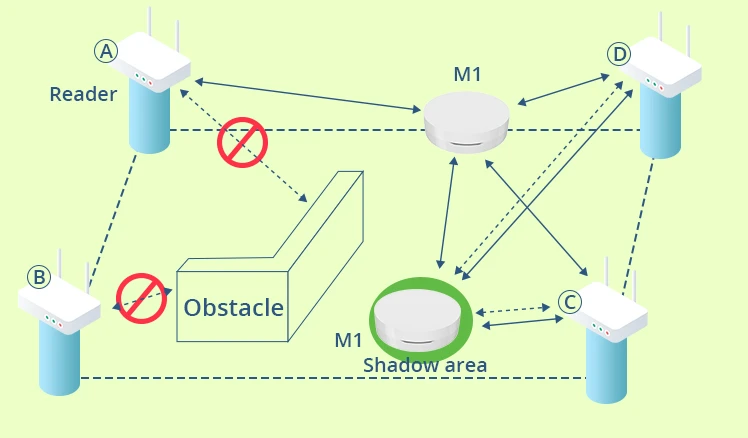
Most RTLS systems need a clear and direct line of sight visibility, allowing them to identify the asset being tracked. If there isn’t enough visibility between the fixed nodes and mobile RTLS tags, the location engine won’t show any results. For instance, satellite location systems require a line of sight between the asset and the satellite. Among the best ways for overcoming the visibility issue is implementing fingerprinting, which might require using transmitters in fairly high saturation.
- Location backlog
Since assets might keep changing their location, any latency from the solution in providing the new location could result in a false location error. If a solution struggles to provide location updates fast enough as needed for a project, it might not be the ideal solution for it.
- Location jitter
The stability of the result could be erratically influenced by noise from different sources. On the other hand, trying to provide a steady appearance will increase latency, which contradicts real-time requirements.
- Location jump
Since mass-containing objects possess limitations to jump, these effects are mostly beyond physical reality. The issue might be improper location engine modeling if the jump location isn’t identifiable with the object itself. This effect can result from a change in dominance for the different secondary responses.
- Location creep
Biased secondary path reflections could result in an object being reported as moving. This effect indicates that there is insufficient first-echo discrimination and can result from simple averaging.
The standards of RTLS system
The International Electrotechnical Commission (IEC) and the International Organization of Standardization (ISO) worked hand in hand to introduce some standardization to the RTLS industry. This ensures that there is some compatibility between RTLS solutions globally while ensuring that quality levels are standardized. Every detail on the standardization is listed under the ISO/IEC 24730 series. Here are the several published standards:
- ISO/IEC 19762-5:2008: Used to provide definitions and terms that are unique to the locating system for data capture techniques and automatic identification
- ISO/IEC 24730-1:2014: Standardizes how software applications can use RTLS to locate assets with the help of attached RTLS transmitters.
- ISO/IEC 24730-2:2012: Defines a single API for RTLS to be used in asset management to encourage product interoperability in the RTLS market.
- ISO/IEC 24730-5:2010: Defines an API and air interface protocol that uses a chirp spread spectrum (CSS) with frequencies ranging between 2.4GHz and 2.483 GHz.
- ISO/IEC 24730-21:2012: defines the compliant RTLS transmitters’ physical layer for those employing a BPSK spreading scheme and DBPSK data encoding while operating with a single spread code.
- ISO/IEC 24730-22:2012: Used to define a network location system that aims to provide data telemetry and X-Y coordinates.
- ISO/IEC 24730-61:2013: Used to define the tag management layer and physical layer of a UWB RTLS air interface protocol that supports an RTLS’ one-directional simplex communication tags and readers.
- ISO/IEC 24730-62:2013: used to define real-time location systems’ air interface utilizing physical layer UWB signaling mechanism.
These standards aren’t meant to stipulate special methods for measuring location or computing location data. The methods used for such tasks include triangulation, trilateration, or common hybrid approaches to trigonometric computing for spherical models or planar in a terrestrial area. The standards are only meant to improve interoperability between global RTLS solutions.
RTLS limitations and challenges
While the adoption of RTLS systems has been increasing, some challenges still hold it back.
- Lack of awareness
Misinformation and lack of awareness have been holding back the RTLS industry from growth. Some users are still dependent on passive RFID and barcodes in areas where RTLS systems could be beneficial. Among the regions with the lowest awareness levels are developing regions like RoW and APAC.
On the other hand, while some organizations might implement RTLS systems, they lack the expertise to fully optimize these solutions. RTLS systems often require having well-skilled technicians who can handle spatial data and deal with any arising issues. The reduction in this barrier has been the reason why APAC countries are slowly adopting the technology.
Manufacturers and service providers have the biggest responsibility – ensuring the public has enough information on the effectiveness of these solutions. They can spread knowledge through trade shows, workshops, or generally good marketing strategies.
- High installation costs
While the RTLS installation costs vary from one industry to another, they are generally high but affordable, especially with specific supporting technologies. For instance, it costs less to install a Wi-Fi-based real time location system than RTLS Arduino and UWB based systems, but the hardware costs are vice versa. On the other hand, it is less costly to maintain solutions running on BLE and UWB than Wi-Fi and RFID.
Installing an RTLS solution isn’t as easy as getting it shipped from the service provider. Instead, it requires customizations to ensure it fits your specific needs and environment. Part of the reason the solutions are highly-priced is that the price of power, wiring, infrastructure, software, and hardware is generally high. The good thing is that hardware prices have been dropping, paving the way for increased adoption.
The future of the RTLS market and supporting statistics
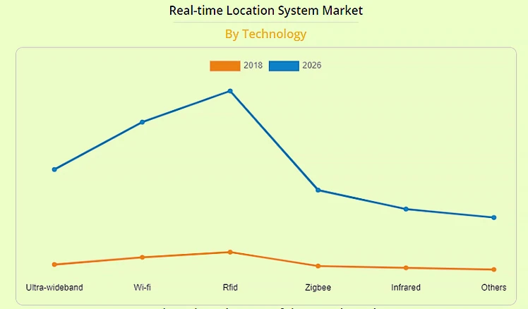
While the global RTLS market was valued at $1.7 billion in 2017, it is expected to be worth $13 billion by 2026 – a CAGR of 25%. The awareness of the specific location of resources and assets through automated asset tracking could help organizations better utilize their resources while optimizing their workflow. The increasing adoption of RTLS solutions is among the reasons the market is expected to have such a high CAGR. When combined with the increasing technological advancements and reduced hardware prices, adoption is meant to increase. For instance, the introduction of Bluetooth 5 will improve the industry immensely.
Hardware components are among the most important parts of RTLS solutions. However, the cost of sensors, transmitters, and tags is high, which has turned this segment into one that generates the most revenue in the market. In fact, it brings in more revenue for manufacturers than services and software. Hardware prices are predicted to drop between 2017 and 2026 (the forecast period). While this will decrease the sale values, it will result in an increase in sale volume.
Wi-Fi has been dominating the global RTLS market, and it is closely followed by RTLS RFID technology. There have been many factors driving this widespread adoption, including the ease of deployment, its low costs, and the improvement in Wi-Fi RTLS bandwidth. On the other hand, RFID has been a champion in helping users improve operational efficiency and effectiveness. With the cost of RFID RTLS expected to drop, it could increase the global demand for this technology within the forecast period.
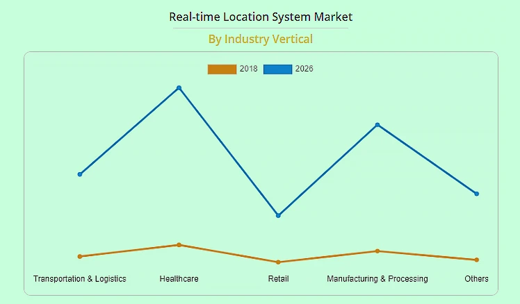
The healthcare industry continues to dominate among the industries that use RTLS solutions and is expected to keep being a dominant user within the forecast period. This industry solidified its spot by being an early adopter of RTLS-based solutions. The solutions are used in various ways within the industry, including tracking personnel and patients, monitoring hand hygiene compliance, monitoring assets, and environmental monitoring. Since many medical facilities lose a lot of cash replacing lost items, RTLS solutions are heavily needed in the industry. Combined with the increasing adoption and growth of IoMT, the healthcare industry is bound to retain its spot as a dominant user of RTLS solutions.
North America dominates the current global RTLS market. The increasing application of the solutions in the healthcare industry combined with government initiatives and support has propelled the adoption of the solutions in this region. However, the APAC region is expected to experience the highest adoption rate, with its CAGR estimated to reach 27%.
The APAC region has embraced and adopted RTLS technology in sectors like manufacturing, healthcare, and retail. Japan has been leading as an early adopter in the region, with countries like China, North Korea, and Australia following closely.
Why more industries are embracing RTLS technology
- The rise in the need for asset tracking
There has been an increasing need to track assets in industry verticals like defense, healthcare, and manufacturing. In most cases, the assets being tracked are medical equipment, tools, trailers, and containers. With most global superpower economies increasing their military spending, it is anticipated that more of them will be investing in real time location services.
- The proliferation of smartphones
The proliferation of smartphones all over the world has been a major driver for RTLS adoption. A number of apps rely on real-time positioning information. Some great examples include business and communication apps, health and wellness apps, gaming apps, and personal convenience apps. Case in point, for smartphones to be used for incident response and emergency management, they have to rely on real-time location systems, which come in handy in identifying and tracking the specific location of people.
- Key RTLS companies blending supporting technologies
Unlike before, when vendors offered closed solution offerings, modern-day lenders combined components and technologies to improve the kind of services RTLS solutions can offer. For instance, there has been a great relationship between Bluetooth Low Energy vendors and Ultra-wideband vendors, which has led to improvements in the functionality of devices. In the case of BLE beacon vendors, most have been trying to extend their devices’ firmware functionalities to improve their hardware devices. With these vendors trying to improve the level of precision every RTLS device can offer, they directly increase application areas for the technology, increasing the adoption rate.
How to get started with RTLS system
There is a lot you need to consider and learn when implementing an RTLS solution. For instance, you should start by establishing the problem you want to solve. You should also identify the technological configurations that will solve your problem best. Some of the other essential factors to consider include:
- The scale of your project
- The kind of real time location system warehouse environment you want to operate RTLS in
- The kind of location precision you desire
- The material, size, and shape of the asset you want to locate
- The frequency of updates needed from the RTLS solution
- The ease of accessing the data the RTLS system generates
While some of these concerns are easy to address through a brainstorming session, others will require consulting an expert or field-testing the solution. Regardless, conducting an RTLS pilot is essential. Introducing the system into your facility for a short time will help you assess the real-world application of the system, as well as how compatible it is with your specific requirements. It could also help you identify concerns you didn’t know you needed to address.
Calculating the cost of RTLS
While RTLS solutions are meant to save cash in any vertical it is applied, implementing it will call for having the right resources and infrastructure. When starting out, finding the ideal solution and an integration partner isn’t always straightforward. You need to first establish what you want the system to achieve. This requires that you judge its performance, budget for the investment, and schedule different appointments. In general, the expenses will include:
- Hardware costs
- Installation costs
- Software licensing costs
- Training and onboarding expenses
- System support and ongoing maintenance
- Data integration and custom development costs
Among the most difficult factors to determine off the bat is ROI, which is an essential part of planning. Establishing a rough estimate of the ROI could help you make the right decision and answer a lot of questions. The good thing with modern RTLS providers is that they look for ways to competitively price their products.
For instance, some vendors will push essential costs upfront while making the maintenance and operation costs affordable. Others will subsidize installation or hardware costs through affordable longer-term maintenance. Establishing the total cost of ownership isn’t always easy, but you can determine it once you identify each cost factor and validate that a system’s performance meets your intended use.
What to consider when implementing RTLS
The different types of RTLS solutions are nuanced, with each having slightly different features from the rest. You should consider the solutions:
- Location accuracy: How precisely do you want the location system to be? You can look for something proximity-based if you aren’t interested in centimeter-level accuracy. A precision-based system will be ideal for situations where you need precise location data.
- Update speeds: your system needs to provide the necessary information as soon as it is needed. Gauge how fast you want to access the data and pick a solution that rhymes with your needs. For instance, an equipment-tracking RTLS solution needs to constantly broadcast its location.
- Scalability: implementing RTLS shouldn’t result in service disruption, either now or in the future. Integrating the new RTLS solution with existing corporate systems should also be easy. If you need to invest in extra infrastructure, the investment cost should be as small as possible. Since some solutions are expensive and require purchasing extra infrastructure, you should at least futureproof the investment to prevent having to purchase extra items in the future.
- Integration capabilities: How easy will it be to integrate a new RTLS system with existing infrastructure? Having cross-departmental compatibility will allow your RTLS solution to be used throughout the organization. In case these are some compatibility issues, fixing them shouldn’t come at a huge cost.
- Reliability: the tags should have reliable batteries and maintain consistent operability. A solution whose devices and tags send proactive notifications about their declining battery life would be ideal to ensure continuous data delivery.
Conclusion
The development of supporting technologies like Bluetooth 5 is good for the RTLS industry. It allows organizations to find new use areas. Thanks to these advancements, RTLS systems are poised to gain massive adoption in the coming years.
CONTINUE READING ABOUT RTLS


")
")

